The following post is reprinted from an article written by Wendy Todd for the SRCC Fall 2015 Neighborhood Newsletter. You can read the full newsletter here.
There are three projects currently underway affecting the South Central Waterfront (SCW): an environmental proposal, an economic analysis, and a streetscape effort. The South Central Waterfront encompasses 97 acres located just south of downtown and bounded by South First on the west, Blunn Creek to the east, Lady Bird Lake on the north, and East Riverside Drive and Bouldin Creek on the south and includes the South River City Citizens (SRCC), and Bouldin Creek Neighborhood Association (BCNA) as well as having portions included in the Downtown Public Improvement District (PID) which is administered by the Downtown Austin Alliance (DAA).
On September 3, at the Texas School for the Deaf, the Environmental Protection Agency (EPA) “Greening of America’s Capitals†team and their consultant CMG Landscape Architecture from San Francisco, CA concluded a 3-day Design Workshop and Open House. Scott Cataffa, PLA, a principal with CMG, presented options that would establish a pedestrian precinct, create public open space, and enhance waterfront connections within and across the 97-acre South Central Waterfront (SCW). According to Alan Holt, AIA, Principal Planner with the City of Austin Planning and Zoning Department, “Those design concepts will provide the skeleton for the envisioned physical network of connected new and improved streets, streetscapes, trails, and open spaces (i.e., green infrastructure) for the SCW.â€
The final report for the design plan should be available in November 2015 and highlights are expected to include a scheme to connect South First Street to South Congress Avenue with a pedestrian and bike trail along Bouldin Creek at the Texas School for the Deaf, a proposal for the Ann W. Richards Congress Avenue Bridge, and a civic gathering space within the proposed street grid overlay. Funding for the implementation of this design overlay is not secured but could prove feasible in the future.
Concurrent with this project, Abe Farkas, PhD with the firm ECONorthwest, has begun work on a City of Austin contract to develop economic models of the SCW which compare the baseline buildout to an alternative buildout that includes the options discussed above in addition to affordable housing. The timeline for the economic study suggests meetings and presentations in December 2015 to be followed by a presentation to City Council in February 2016.To view the presentations and keep current with new information please consult http://www.austintexas.gov/waterfront and subscribe to the SCW list serve.
Early 2016 will also see the kickoff for the public engagement and design team work for the Congress Avenue Urban Design Initiative. The $2 million 2012 bond initiative begins at Riverside Drive and terminates at the Capitol. South River City Citizens, while not identified as stakeholders, should consider involvement in this project since the Austin-American Statesman property owned by the Cox Media Group is within SRCC boundaries in addition to being a part of the Downtown Public Improvement District (PID).
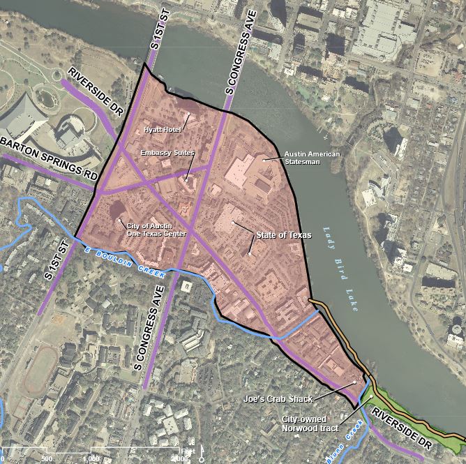
Source: City of Austin South Central Waterfront Initiative.


